Research
Research Methods
Lions and The Trans Kalahari Predator Programme
History and Milestones
Cecil the Lion & WildCRU’s Cecil Summit
Area of Operation
Lion Ecology
Monitoring Populations
Transboundary and Landscape Conservation
Human-Lion Coexistence
Research Methods
The Team
Sponsors & How to Support Us
References
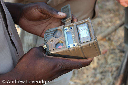
Camera-trap survey
Camera-trap surveys are a well-established, non-invasive and effective survey technique that has been used to estimate carnivore population densities across various areas in Africa and the world. The population sampling technique is based on the sound statistical framework known as capture-mark-recapture. It allows for the mathematical estimation of population sizes if a fraction of the captured animals can be individually identified and periodically recaptured. Motion sensor-triggered camera traps are installed along roads or animals trails and record pictures of anything moving past. Individual animals are identified via unique spot patterns and/or physical characteristics such as scars, size, weight and mane colour.
Since 2010, the TKPP has conducted extensive camera trap-based carnivore surveys in Zimbabwe and Botswana. The team extensively surveyed a large variety of protected areas, including National Parks, Game Reserves, Wildlife Management Areas and private wildlife concessions. 2017 further marked the beginning of the Okavango Delta Large Carnivore Survey, which aims to produce a sound and comprehensive estimate of large carnivore population sizes for this world-renown UNESCO World Heritage Site.
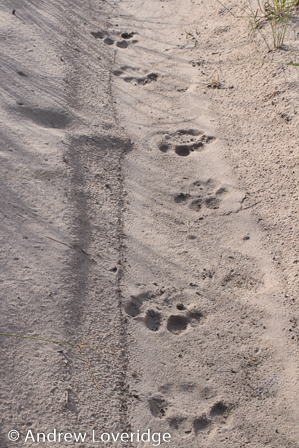
Spoor count surveys
Large carnivores often travel along roads, and the sandy coverage in many habitats is highly suitable for spoor detection and identification. Spoor counts have been identified as a reliable and cost-effective method to measure relative abundance of carnivore populations, while being repeatable and objective. The general applicability of using spoor-based indices to estimate carnivore abundance has been tested across a wide geographical scale and a large range of carnivore densities and has shown a strong linear relationship between spoor frequency and the density in which animals occur. With the assistance of experienced local trackers, individual spoor of adult carnivores are being identified and used to calculate carnivore densities and occupancy.
GPS movement data
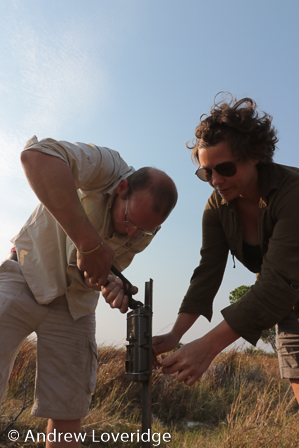
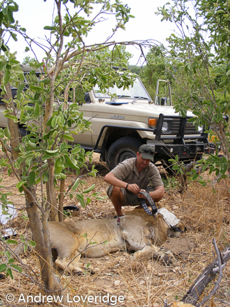
The technology of GPS satellite tracking is developing rapidly and enables scientists all over the world to collect a considerably larger amount of data from a larger area in a shorter period of time. Where in the past scientists spent a lot of time following every single animal individually to record their movement and behaviour, desperately trying to not lose sight when following through thick bushland, we can now continuously collect a lot of this data from many different individuals at the same time. Technological improvements are therefore a fantastic development to speed up informative data collection. It enables us to act and react faster and increasingly targeted-oriented to drive lion conservation at a landscape-scale by providing scientifically sound guidance to policy makers.
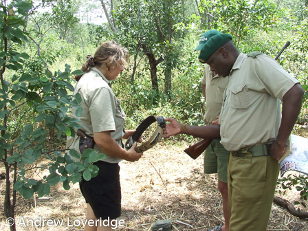
To facilitate such larger scale data collection, lions are fitted with GPS satellite collars and recorded data is being transferred straight from the collars to data analysis software via advanced satellite technology. Lions can be “caught” in many different ways, including foot snares, cage trapping or using bait. However, to reduce stress to an absolute minimum, we free-dart study animals at calling stations or when located opportunistically during the day. An experienced and licensed wildlife veterinarian conducts the darting and animal welfare is a top priority at all times.
The Team >>