
WildMAPS is a repository and visualisation tool for habitat suitability models generated by WildCRU and its large network of collaborators from around the world. The models are built upon several hundred thousand detection data points from the Earth’s most biodiverse and threatened ecosystems. Individual models predict species distribution and suitable habitat for key taxa of conservation concern.
CONSERVATION CONTEXT
Habitat suitability models are valuable for making predictions on the distribution of wildlife. This approach is especially useful for species threatened by habitat loss, or landscape change, often driven by human development. We designed WildMAPS to connect conservation practitioners with the most up to date scientific spatial predictions for the species we study and facilitate access to data and information through an easy dashboard. It is our hope that these maps will support landscape planners and other stakeholders to develop a quantitative approach to conservation planning based on scientific evidence.
APPROACH
For each habitat suitability model in the repository we provide a link to the original publication so that users can refer to the scope and limitations of the approach and the environmental variables that were used in each study. Our aim is to make the spatial information generated by each study accessible as maps to a wide range of stakeholders. Each model is presented at relevant scales and resolutions for the conservation context of the target species or taxa.
How to use habitat suitability models
Models are statistical functions that relate observed datasets, to their predictors. Habitat suitability models relate data on animal detections, or movement data, to the environmental variables that best predict them. Models are not exact representations of reality, but they offer us a quantitative basis for understanding the relative impact of environmental or management changes on entire ecosystems.
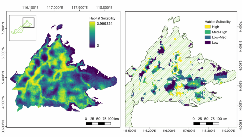
Example Habitat Suitability Model
As an example, the figure below shows the most recent habitat suitability model for Sunda pangolins in Sabah, Malaysian Borneo (left). From this habitat suitability, we were able to analyse the proportion of suitable habitat for Sunda pangolins that are found within protected areas (right).
The model was constructed using 6 predictor variables, each of which had coefficients that determine the individual “effects” of those predictors to the overall model. The 6 predictors in this particular model was soil bulk density, soil cation exchange capacity, soil clay composition, soil nitrogen concentration ,topographic position index and accessibility to human population. Predictions, therefore, are made using the following general equation (where b=predictor coefficient and c=pixel value).
![]()